by Yash, age 6, Hong Kong.
"My map has a castle with a king and some soldiers. There is a road that takes us from the castle to the stable, the village and the rotten cars place."
This is a fantastic arial view you designed. It shows us perfectly how to navigate from castle to stable to village. I especially love all the details like the soldiers, the little houses and the vehicles.

by Bryn age 8 and Emi age 6, Figanières, France.
"This is an imaginary map. The map is from a magical land. There is a blue pond and grass. There is also grey gravel surrounding the grass. We made two ships that take you around the park. They float above the ground. There is a little house at the park. There is a person riding their bike on the road leaving the pond. This is a bird's eye view of our park."
Awesome arial perspective! This is similar to google maps in that it captured all the people doing their everyday things like biking. I really like all the bike racks and the beautiful park. Wonderful collaborative effort!
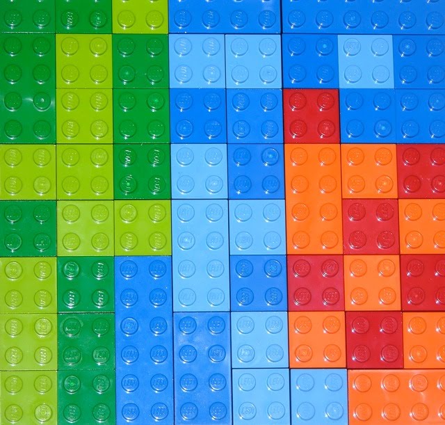
"This is a map showing different land types. There is grasslands, the ocean and the desert. The darker green is the thicker forest portion, the darker blue is the deep spots in the ocean, and the red spots are the really really hot portions of the desert."
Great geological map! You've symbolized each type of surface with a different color, making it very easy for us to differentiate the different land types. I especially like that you used varying shades of the same color for more detailed contrasts.

by Aaron, age 6, Tucson, Arizona, USA
"This is a map of a trail. You can see the map to the side of a cabin you see at the start of a trail. The red circle on the map means "you are here". The areas with lines going up and down and to the side are farmlands. In front of the cabin you can see the yellow trail that is on the map."
This reminds me of going on nature walks and looking at the 'you are here' maps along the way. This creation shows clearly where the trail is, and how to get to the cabin in relation to the walking path. Great design!

"It is a treasure map and the three pirates are going to get the treasure. The treasure is near a river and a sidewalk, between two train cars."
Fantastic large X marks the spot! The pirates are so close to the area where they need to start digging. Cleverly hidden between two trains, an unlikely place for a treasure. Very cool!

"Avery is sending in a map of his home state, Indiana. He has labeled some of the bigger cities in Indiana. He also labled Bloomington, where we live!"
Fabulous territorial map! This design shows clearly the political borders of Indiana! I really love how you've marked some of the major cities with small bricks and a single stud on top. Adding your written city names really brings this creation over the top!

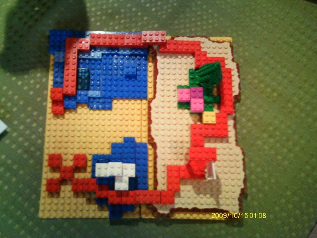
"This is a topographical (3D) map of a canyon trail. The black part is a restroom ("Great Relief Hall") and the different colors are different trails. The white is the canyon wall and the tall pillar in the center is a carved rock. The rock is so tall it reaches out of the canyon."
This is a great topographic map with the added feature of letting you know where the high and low points are with the addition of 3D. Hilarious that you named the restrooms "Great Relief Hall"! Smart use of different colors to show different trails to hike on.

"The whole land used to be a desert, but then the forest took over most of it leaving a little bit of desert. Then the ocean flooded most of the land. This map is in Asia. The icebergs in the ocean show it goes up to the North of Asia."
Fabulous geological map. This design clearly shows the different land types. Desert, forest and ocean. Interesting how the desert has been overgrown by forested areas and the ocean has enveloped most of this land mass due to flooding.

"Treasure Map"
"A bad guy buried chocolate coins on the beach. This is the treasure map that shows how to find it under the white circle. The guy on the map is me, and I have a walkie-talkie and a shovel to dig up the treasure. The blue stuff is water and there is a yellow and green coconut tree. When I find the treasure I'm gonna eat it up!"
How cool that you actually buried treasure you can eat! I love seeing LEGO pieces half under the sand, they look so interesting. Installing your creation outdoors takes this design to a new level. Great treasure map!

by Samuel age 5 and Sawyer age 3, North Carolina, USA.
"This is Morton Town. We live in the house surrounded by the beautiful flower and vegetable gardens. It is summer here in Morton Town and we are looking forward to a great harvest this year. Further down the map shows the Super Target where we can get anything we might need. Follow the path and you will come across our towns lake that is stocked with fish waiting to be caught. An enchanted forest is next on the map, but beware for there is some kind of strange creature lurking in the shadows of the trees. Next stop on the map is the YMCA where we can play soccer, baseball and basketball. Our church is in between my house and the YMCA. I love Morton Town."
Wow, Morton town has everything to live a happy, busy life, surrounded by beauty! I love how you used the thin LEGO bricks to show a pathway to all the different amenities of this lovely town. This looks like the perfect map of the things you enjoy in your life!

by Reece age 8, and Cole age 4, Nova Scotia, Canada.
"This is a map of Nova Scotia. The red roof is our house. I am in blue pants, blue shirt and a blue cap. My brother is in the black pants, white shirt and black cap. The fireman is in there because he lives close to us. The other people are some of my friends."
Great to see you've put yourself, brother and some of your friends and neighbours in your map. This is like a random google maps photo showing all of you walking down your street. Great collaboration!
"It's a treasure map. The red path leads to the X where the treasure is."
Awesome treasure map! I love the red path and the way you constructed the X. The path seems to go through water, sand and treed areas, taking you on a bit of a wild goose chase instead of going straight. Very cleverly hidden!

"It's a map of Africa. Yellow is desert, red is scrubland/semi-desert, light green is savannah, dark green is jungle, black is mountains, and blue is water."
Fabulous geological map! You have shown such diverse land types in this creation. This shows us clearly what to expect when travelling to this area of the world.

"This is a plan for a theatre where the Firebird will dance her ballet in (I think the double row of blocks - with the plant - is the stage, the single row of blocks opposite is a balcony)."
How wonderful that you mapped out the theatre! this would help the dancers see a different perspective on their performance space. Nicely done!

"This is a 3D map of Mt. Everest. You can see it is helpful for helicopter pilots."
This would be such a helpful map for anyone wanting to navigate Mt. Everest. It would show you all the key points and routes when climbing. Extremely important for rescue missions! I love that you've shown a helicopter flying over top.

"This is a treasure map. There is a volcano and a docked pirate ship. The yellow parts are beaches. The clear piece is the lava soaking into the sand."
I just love the Jolly Roger flag you designed. What a great personal touch. The locations of the beaches are very smart, always where the land and water meet. I really like how you designed the X marks the spot! Very nice map!

"This is a map that I created and where you see the two brown blocks, that is where you start. Then the red lego bricks go into a line, those are the lines you have to follow. There is an 'X' under the two skeleton treasure guards and they are fighting a guy who is trying to get the treasure. The guy is kicking one of them, and I put a support behind the skeleton treasure guard so he could lean and look like he was falling. The red fabric is lava."
Great pirates treasure map! I love the action you created of your mini figure kicking the skeleton. The leaning really makes it look like it is falling over! Smart use of support system to keep the skeleton propped in place. It's great that you actually have a treasure chest.

"This a globe. It is nowhere in particular. Most of it is covered in trees. The brown dot in untreed land. The rest of it is just ocean."
This is such a great design. It is unlike any other creation that was submitted for this challenge. I really love how you created the whole globe and approached your construction in an 'in the round' fashion. This allows your viewers to see it from all angles, top, bottom, any side. It is free standing and had to be designed to look good from all directions. Very clever.

by Lyric age 7 and Emmet age 3, Oklahoma, USA.
"This is the map to my daddy's work. There are gas stations and there is my daddy at his work. He has his truck and a tall building for his work. And the yellow block is my home with my brother and I standing out front. That is my map!"
This is a great map of how your dad goes from your home to work, maybe stopping for gas on the way. I really like the pattern you used to show his route with the thin yellow, white and black bricks. Nicely designed and great collaboration!